

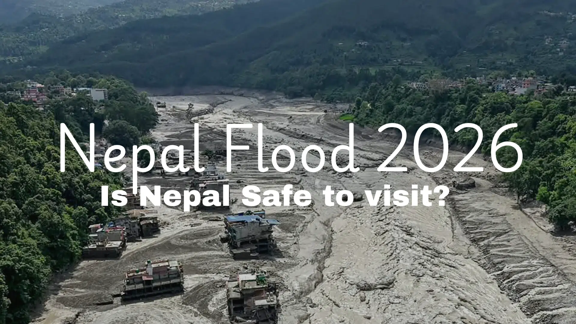
Updated with the latest available figures as of early September 2026
“There are disasters you read about, and then there are disasters that a whole country stops to grieve together. The Nepal flood 2026 which tore through the Bhote Koshi and Trishuli river corridor in the country’s north on the morning of August 26 belongs to the second kind. Within a few hours, a mountain that had stood quietly for thousands of years let go of a piece of itself and by the time the water, ice, mud, and rock finished moving, entire settlements had been erased, a border crossing was gone, and thousands of families across two countries were left waiting for news that, for many, would never come.” I wanted to put together everything that’s actually known right now not rumors, not recycled headlines, but the details as reported by the people on the ground, the scientists studying the satellite images, and Nepal’s own disaster authorities. This is long, because the story deserves it.
It Didn’t Start With Rain , It Started With a Mountain Falling
Here’s the part that surprised almost everyone, including seismologists thousands of kilometers away: this wasn’t a normal monsoon flood, and at first, nobody even thought it was a flood at all.
At 8:37 a.m. local time on August 26, seismic stations on every continent picked up a jolt originating high in the Himalaya, near a peak called Langtang Lirung, right on the Nepal-China border. For a little while, officials in both Kathmandu and Beijing genuinely believed they were looking at an earthquake. They weren’t.
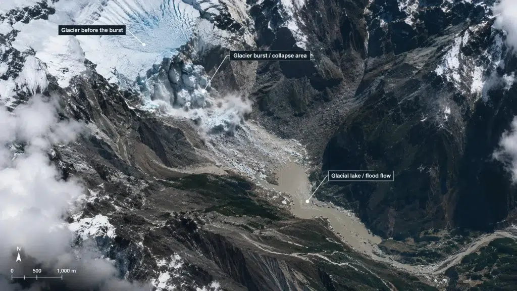
What actually happened, based on satellite analysis by glaciologists at ICIMOD (the Kathmandu-based International Centre for Integrated Mountain Development) and other research groups, was this:
- A huge slab of glacier together with the bedrock underneath it broke away. This is an important detail that only emerged a couple of days later, once clearer satellite images cut through the cloud cover: it wasn’t just ice that failed, but a chunk of the mountain itself, roughly a fifth of a square kilometer in size, more than a kilometer wide.
- It fell from about 5,200 meters altitude, plunging roughly 1,200 meters down the mountainside, picking up rock, boulders, and sediment as it went turning into a fast-moving rock-and-ice avalanche.
- The avalanche slammed into the Lhende River on the Tibetan side of the border, about 20 kilometers from the Rasuwagadhi border crossing, and the sheer volume of debris briefly dammed the river.
- When that makeshift debris dam gave way, it released a sudden, violent surge of water, mud, ice, and rock down the Lhende Khola into the Bhote Koshi and Trishuli river systems — and from there straight into Nepal’s Rasuwa, Nuwakot, and Dhading districts.
So this wasn’t melting ice gradually turning into a flood, and importantly scientists have said it was not a Glacial Lake Outburst Flood (GLOF) in the classic sense either, where a natural lake dammed by a glacier bursts. This was closer to what one researcher called a “rock–ice avalanche and debris-flow cascade.” Nepal’s own foreign minister gave it a more visceral name that’s stuck in headlines since: a “Himalayan tsunami.”
Scientists are being careful here, and it’s worth being careful too: while climate change is clearly driving rapid glacier retreat and instability across the Hindu Kush Himalaya region, and researchers note that events like this are becoming more frequent as previously “stable” glaciers show new cracking, experts have said it’s still too early to definitively pin this specific collapse on global warming. It may also reflect underlying geology the bedrock failure as much as climate. Both explanations are being investigated.
Whatever the precise cause, the outcome was the same: a wall of ice, mud, and boulders that reached Chinese territory within minutes, and Nepal’s populated valleys within hours.
Most Affected Areas
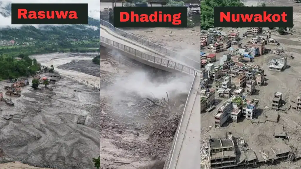
The flood followed a roughly 72-kilometer stretch down the Trishuli and Bhote Koshi rivers, and the destruction concentrated in a few very specific places:
- Rasuwa district (Nepal) took the brunt of it. The border settlement of Timure and the town of Syabrubesi, the gateway to the popular Langtang trekking region, were among the hardest-hit. The Rasuwagadhi border crossing and the Gyirong Port trade route into China were both devastated road access, bridges, customs infrastructure, hydropower stations, all badly damaged or destroyed.
- Nuwakot district next in line as the water moved downstream, with the town of Trishuli heavily affected. Mud and silt buried buildings, vehicles, and an electrical substation.
- Dhading district also hit as the flood continued downstream.
- On the Tibetan (Chinese) side, Gyirong County bore the impact, with the border port there badly damaged and mudslides continuing to threaten the area for days afterward.
Some numbers that give a sense of the physical scale of destruction: at least 53 suspension bridges damaged from Timure to Muglin, with repairs underway on 20, with 28 needing full replacement; 41 bridges and roughly 42 kilometers of road damaged along the immediate corridor; more than 300 vehicles that were waiting at the border swept away entirely. 933 workers were unaccounted for in the Upper Trishuli 3A tunnel alone, and Nepal’s Independent Power Producers’ Association said 934 people across 11 different hydropower projects were missing in total.
Roughly 1.6 million people across the affected regions were impacted in some way, according to a Nepali government report.
The Human Toll Latest Confirmed Numbers
This is the part I want to be most careful and precise about, because the figures have been climbing steadily since August 26 and different sources have reported them at slightly different moments. Here’s the most recent, most credible picture as of early September 2026:
Deaths:
- Nepal: the confirmed death toll reached 1,287 according to Nepal’s National Disaster Risk Reduction and Management Authority (NDRRMA) on September 4, and was reported at 1,280 in an Al Jazeera update around September 6.
- China (Tibet/Gyirong County): 21 deaths confirmed on the Chinese side, according to state media updates (this number rose from an earlier figure of 16).
- Combined Nepal + China toll: around 1,308 confirmed deaths, per figures reported September 4.
- India: at least 17 bodies have been recovered from rivers in northern India, which officials believe floated downstream from Nepal. Notably, these are not currently added to the official combined death toll.
Missing:
- Nepal’s disaster authority listed 5,083 people unaccounted for as of September 4 ,a list that includes 2,130 people from Rasuwa district and 2,340 from Nuwakot district alone. Officials have cautioned this list may also include unidentified bodies already recovered but not yet matched to names.
- On the Chinese side, 541 people remained unaccounted for as of the same period.
- Combined missing figure across both countries: roughly 5,624 people as of September 4, though some reports in the days around September 6 cited figures closer to 4,500–5,000, reflecting the fact that identification and reunification work has been ongoing and numbers shift daily as people are found alive, confirmed dead, or crossed off lists after making contact with family.
Foreign nationals: This is one of the more heartbreaking threads of the story, because the timing peak trekking and pilgrimage season — meant the flood hit an area full of international travelers.
- Nepal’s official disaster authority count listed 583 foreign nationals among the missing as of September 4.
- A separate Reuters-sourced report put the number even higher, at more than 800 foreigners unaccounted for, a figure that includes trekkers in the Langtang/Himalaya region as well as pilgrims many of them Indian who had traveled to Mount Kailash in Tibet, a site sacred to both Hindus and Buddhists.
- In the immediate aftermath, the Nepal Tourism Board had placed 384 travelers (291 foreign nationals and 93 Nepalis) on a preliminary “whereabouts unconfirmed” list.
- The U.S. State Department said it was tracking around 75 Americans unaccounted for across the Nepal-Tibet border region.
- As search operations continued, there was some genuinely good news mixed in: several “missing” tourists were later confirmed to have made contact with family or been found safe, and Nepal held symbolic funerals cremating effigies made of kush grass, in accordance with Hindu ritual for those still feared lost but not yet recovered, so families would have a way to grieve.
Injured and rescued:
- 5,397 people injured, receiving treatment across hospitals and through Nepali Army and Armed Police Force medical teams. At least 4,070 people had received medical treatment as of an early-September count.
- 13,093 people rescued and brought to safety by security forces, including 303 foreign nationals.
- The Nepali Army alone had conducted 830 helicopter flights for rescue and relief operations, with the private sector contributing another 129 flights.
I want to be upfront about something: these are the most recent and best-sourced figures I could find, but they are genuinely still moving. Nepal’s disaster authority itself has described several of these as preliminary. If you’re using these numbers publicly, it’s worth linking your source and noting the date, because the death toll in particular has risen almost every day since the disaster.
The Economic Damage
Beyond the human cost, the flood has hit Nepal’s economy hard, and in a region that was already relatively poor and dependent on tourism, trade, and hydropower.
- Nepal’s disaster authority chief gave an initial estimate of at least 387.5 billion Nepalese rupees (about $2.56 billion) in lost property, housing, and infrastructure explicitly described as a preliminary figure pending a full assessment.
- Nepal’s finance minister has said that full reconstruction could cost close to $6 billion once every loss is properly assessed a number independently echoed by outside analysts, who point out that this is nearly one-third of Nepal’s entire annual national budget.
- Just repairing damaged roads and bridges along the corridor alone is estimated at roughly 15 billion rupees (about $99.4 million).
- For the first four months of early recovery work alone temporary shelters, roads, drinking water, restoring power the government estimates around $52.6 million will be needed.
Small and medium businesses along the Rasuwa-Nuwakot-Dhading corridor, hydropower projects, farmland, and the cross-border trade route through Gyirong Port were all hit meaning the economic ripple effects will likely be felt in that region for years, not months.
Is Nepal Safe to Visit Right Now?
I know this is probably the question a lot of people actually came here for, especially with autumn Nepal’s peak trekking and tourism season approaching. Here’s the honest, detailed answer based on the latest tourism advisories.
Short answer: yes, Nepal as a whole is open, and most of the country was never affected by this disaster at all. This was a serious but geographically contained event — a specific river corridor, not a nationwide crisis. Tribhuvan International Airport in Kathmandu has kept running a normal schedule of domestic and international flights throughout the entire response effort, which tells you a lot about how localized the actual damage is.
Regions that are open and considered safe
- Kathmandu Valley (Kathmandu, Bhaktapur, Patan) — unaffected, operating normally.
- Pokhara — unaffected.
- Chitwan and Lumbini — unaffected.
- Everest region (Khumbu/Solukhumbu) — fully open. Namche Bazaar, the main gateway town, has continued welcoming trekkers throughout.
- Annapurna region — fully open.
- Manaslu region — fully open.
- Upper Mustang — fully open.
- Kanchenjunga and Makalu regions — also confirmed open and operating normally.
These regions sit on entirely separate river systems from the Bhote Koshi/Trishuli corridor, which is why they were physically untouched by the flood. Multiple trekking operators with decades of on-the-ground experience in Nepal (some who’ve guided through the 2015 earthquake and previous monsoon disasters) have said their departure schedules for these regions are unchanged.
The one region you should treat with real caution
- Rasuwa district, specifically the Rasuwagadhi–Timure–Syabrubesi corridor, including the Nepal-China border crossing there. This is the actual disaster zone.
- The Langtang trekking region, which is accessed via Syabrubesi, is in a genuinely mixed situation worth understanding properly: multiple trekking companies have clarified that the Langtang walking trail itself, up the Langtang Khola valley, was not directly flooded. The damage is to the access road and the Syabrubesi gateway, not the trail deep in the valley. That said, both the U.S. State Department and Nepali authorities currently advise against travel into this specific corridor while recovery and safety inspections continue, and local operators estimate the route may not be reliably workable again until late September 2026, weather and inspections permitting described explicitly as an estimate, not a guarantee.
- If you already have a Langtang or Gosaikunda trek booked for this season, operators are being direct that this needs an actual one-on-one conversation with your operator rather than a general “don’t worry” reassurance, since it’s the one itinerary genuinely affected.
Sensible precautions if you’re traveling to Nepal this season
- Check official sources directly rather than relying on secondhand summaries: the Nepal Tourism Board, your home country’s travel advisory, and your trekking operator.
- Book only through licensed, government-registered operators.
- Keep the Nepal Tourism Board toll-free number (1234), the hotline (1144), and Tourist Police (+977 9851289445) saved before you fly, especially if trekking near any northern border region.
- Get travel insurance that specifically covers high-altitude trekking and helicopter evacuation — standard policies often exclude coverage above a certain elevation.
- Remember that ordinary monsoon-season landslide and road risk still applies country-wide, independent of this specific flood — always check current road status before overland travel, regardless of destination.
So: Nepal is not “closed.” One specific corridor in one district is the area to avoid or approach with real caution, and everywhere else on the standard tourist and trekking map — including the country’s biggest draws — remains open and, per operators on the ground, genuinely eager to welcome visitors back as autumn season begins.
Nepal Flood 2026: A Country in Mourning, and Rebuilding
What strikes me most, reading through weeks of reporting on this, is the scale of the response alongside the scale of the loss — mass burials held for over a thousand people, symbolic funerals for families who may never get a body to bury, thousands of rescuers and hundreds of helicopter flights, and a government now trying to shift from emergency rescue toward the much longer, harder work of rehabilitation.
Nepal’s prime minister has already spoken about beginning that shift toward rehabilitation, even as search operations continue in some of the most remote, hardest-to-reach mountain villages. It’s a country that has been here before — the 2015 earthquake, the 2024 floods — and is being asked to absorb another devastating loss while still welcoming the tourism industry that so many of its mountain communities depend on for their livelihoods.
If you’re posting about this, sharing it, or just trying to understand it: the numbers above are the most accurate available right now, but they will keep changing. Link your sources, date your figures, and if you want to help, look toward established relief organizations working directly in Rasuwa, Nuwakot, and Dhading districts rather than unverified fundraisers.
Sources referenced: NDRRMA (Nepal’s National Disaster Risk Reduction and Management Authority), AP News, Al Jazeera, BBC, CNN, Reuters, The Guardian, ABC News, UN News, ICIMOD, the Sasakawa Peace Foundation’s “The Langtang Collapse” research brief, OnlineKhabar, The Kathmandu Post, The Diplomat, and multiple Nepal-based trekking operators’ official advisories. Figures are current as of early September 2026 and are expected to continue changing as recovery efforts proceed.
